Severe Weather Alert Issued as Dangerous Storm System Moves Across NSW
Authorities warn flash flooding is possible tonight as slow-moving thunderstorms dump heavy rain across large parts of New South Wales and the ACT.
Storm Warning Triggers Urgent Alert Across Multiple Regions
A major weather warning has been issued for large parts of eastern Australia as powerful thunderstorms bring heavy rainfall and the risk of flash flooding across New South Wales and the Australian Capital Territory.
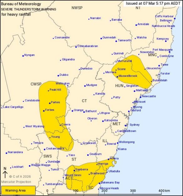
The Bureau of Meteorology (BoM) issued an urgent Severe Thunderstorm Warning late Saturday afternoon as slow-moving storm cells began intensifying across several regions.
Forecasters say the system has the potential to deliver dangerous downpours capable of triggering flash flooding within hours.
Residents across multiple districts have been told to stay alert as conditions continue to evolve rapidly.
Heavy Rain Already Falling Across NSW
According to the weather bureau, thunderstorms began forming earlier in the afternoon as a low-pressure trough combined with unusually high atmospheric moisture across the southeast of the state.
The result is a cluster of slow-moving storms capable of dumping intense rainfall over short periods of time.
Some areas have already recorded significant rainfall totals.
Recent measurements include:
- 35mm in just 30 minutes at Majors Creek
- 51mm in one hour at Parkes Airport
- 61mm in two hours at East Kangaloon
- 33mm in one hour at Orange
Meteorologists say these figures demonstrate how quickly conditions can deteriorate during severe thunderstorms.
When rainfall falls this rapidly, local drainage systems can become overwhelmed, leading to sudden flash flooding even in areas not normally prone to floods.
Areas That Could Be Hit Next
The warning currently covers large parts of central and southeastern New South Wales, including communities across the Hunter, South Coast, and Central Tablelands.
Locations that may experience dangerous storms tonight include:
- Nowra
- Canberra
- Scone
- Parkes
- Braidwood
- Young
Authorities say the system could also intensify further depending on how the storm cells interact during the evening.
If storms begin developing near major population centres such as Sydney, Newcastle or Wollongong, a more detailed severe weather warning may be issued later tonight.
Emergency Authorities Urge Residents to Take Precautions
The NSW State Emergency Service (SES) has issued several safety reminders as storms continue moving across the state.
Officials warn that flash flooding can occur extremely quickly during severe thunderstorms, often with little warning.
Residents are being advised to:
- Stay clear of creeks and storm drains
- Avoid driving through floodwaters
- Remain indoors and away from windows
- Keep children and pets safely inside
Anyone trapped by rising floodwaters is urged to move to the highest available location and call emergency services if rescue is needed.
For emergency assistance during storms or floods, residents can contact the SES on 132 500.
Extreme Weather Becoming More Frequent
Severe storm warnings like this are becoming increasingly common across Australian news and weather reports, particularly during periods of high humidity and unstable atmospheric conditions.
Meteorologists say Australia’s changing weather patterns are contributing to more intense short-duration rainfall events, even outside traditional storm seasons.
While these storms may only last a few hours, the impact on communities can be significant, particularly in rural towns where drainage infrastructure may be limited.
Flash flooding can damage roads, isolate communities and disrupt transport and emergency services.
Residents Turning to Apps and Social Media for Updates
As the storms developed Saturday afternoon, many residents began sharing photos and radar images online showing dark storm clouds and heavy rainfall sweeping across regional NSW.
Authorities are encouraging residents to monitor official updates through the Hazards Near Me NSW, which provides real-time warnings and emergency alerts.
The next official weather update from the Bureau is expected later this evening as meteorologists continue tracking the storm system.
What Happens Next
Weather experts say the next few hours will be critical as the storm system continues moving across southeastern New South Wales.
If thunderstorms begin to intensify or stall over populated areas, flash flooding risks could increase quickly.
Emergency services are urging residents to remain cautious and prepared as the weather situation develops.
For many communities, the question now is how severe the storms will become overnight.
What do you think about this situation? Have storms hit your area yet? Let us know in the comments.